
Change Coordinate System
Description
This activity changes the coordinate reference system (CRS) of a geometry or geopoint column.
Input
Data
Output
Transformed Data
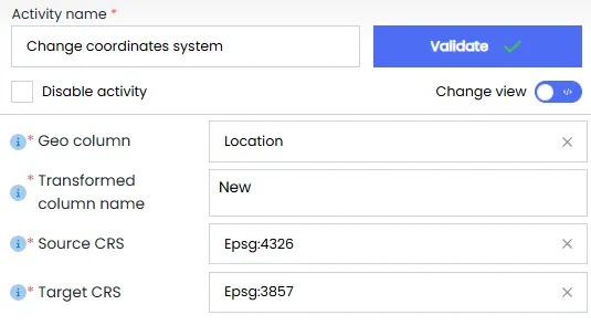
Configuration Fields
- Geo column The input column containing geopoints.
- Transformed column name The output column for the transformed geopoints.
- Source CRS The current coordinate reference system (CRS) of the input data (e.g., EPSG3857 or EPSG4326).
- Target CRS The CRS to which the data will be transformed (e.g., EPSG:3857 or EPSG:4326).
Sample Input
| ID | Location |
|---|---|
| 1 | 12.9716,77.5946 |
| 2 | 34.0522,-118.2437 |
| 3 | 48.8566,2.3522 |
| 4 | 51.5074,-0.1278 |
| 5 | 40.7128,-74.0060 |
Sample Configuration
Sample Output
| ID | Location | New |
|---|---|---|
| 1 | 12.9716,77.5946 | 1.4283e+06,1.2873e+06 |
| 2 | 34.0522,-118.2437 | -1.3172e+07,4.0281e+06 |
| 3 | 48.8566,2.3522 | 2.6207e+05,6.2359e+06 |
| 4 | 51.5074,-0.1278 | -1.4215e+04,6.8499e+06 |
| 5 | 40.7128,-74.0060 | -8.2390e+06,4.9786e+06 |